Topologis vs ArcGIS Online
ArcGIS Online is the dominant enterprise GIS platform. Topologis is built for the last step - publishing finished maps to clients and stakeholders without per-user seats, credit accounting, or platform onboarding.


Side by side
ArcGIS Online is a powerful enterprise GIS platform with raster, spatial analysis, dashboards, surveys, field workflows, APIs, and integrations across the full Esri ecosystem. Topologis is built for a more specific workflow: publishing prepared GIS data as interactive maps that are easy to share, embed, and hand off.
Data
ArcGIS Online accepts a wider range of formats and connects to the full Esri ecosystem and cloud data warehouses. Topologis accepts the formats consultants commonly deliver in, with first-class Google Sheets and no credit metering on storage.
Topologis | ArcGIS Online (Creator) | |
|---|---|---|
| Vector formats (.shp, .gpkg, .geojson, .kml) | ||
| Raster | ||
| CSV / spreadsheets | (CSV, Excel) | |
| Google Sheets (live) | Workaround via published CSV URL | |
| Esri / OGC services (FeatureServer, WMS, WMTS, WFS) | ||
| Data warehouses (Postgres, Snowflake, BigQuery, S3) | (Data Pipelines) | |
| Import from URL | ||
| Scheduled / automatic refresh | (Data Pipelines, Pro overwrite) |
Editing & styling
ArcGIS Online is the stronger choice for in-browser GIS work: real spatial analysis, raster, geocoding, attribute editing, and Arcade-driven smart mapping. Topologis assumes that work happens upstream in QGIS, ArcGIS Pro, or PostGIS and focuses on the publishing layer instead.
Topologis | ArcGIS Online (Creator) | |
|---|---|---|
| Data-driven color & size (numeric, categorical) | ||
| Heatmaps | ||
| Hexbin with 3D extrusion | (Scene Viewer) | |
| Create and edit features in browser | ||
| Annotations (notes, photos) | ||
| Spatial transformations (buffer, clip, dissolve) | (consumes credits) | |
| Geocoding (batch) | (consumes credits) | |
| Raster styling |
Sharing
Both platforms support public maps and embeds. Topologis adds per-view configuration of which filters and layers each audience can control, PIN-protected links, and domain-locked embeds. ArcGIS Online achieves similar audience targeting through separate Instant Apps or Experience Builder apps per audience.
Topologis | ArcGIS Online (Creator) | |
|---|---|---|
| Share via URL | ||
| Invite collaborators | (named users) | |
| Embedded maps | ||
| Per-view filter & layer config | Separate Instant App per audience | |
| PIN-protected links | ||
| Domain-locked embeds | ||
| Time sliders for viewers | ||
| Data filters for viewers | ||
| API, SDK | (REST API, JS SDK, Python) |
Pricing & access
ArcGIS Online combines per-user-type seats with a credits meter that bills storage, geocoding, routing, and analysis. Topologis is one flat per-seat price with included storage and no credits.
Topologis | ArcGIS Online (Creator) | |
|---|---|---|
| Pricing | $23/mo per seat, billed annually $29/mo per seat, billed monthly | ~$58/mo per Creator, billed annually ($700/yr US, not published publicly by Esri) |
| Internal viewers | Free, no seat required | Paid Viewer seat (~$110/yr) required to log in to internal content |
| Public viewers | Unlimited, anonymous | Unlimited, anonymous (when shared publicly) |
| Data hosting | 10 GB per seat, included | Metered in credits ~$24/mo per GB for hosted feature layers |
| Credits / metered services | None | Geocoding, routing, analysis, premium content, storage |
| Trial | 14 days, no credit card | 21 days |
Switching from ArcGIS Online?
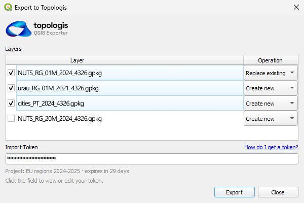
Topologis imports the formats AGOL already exports - Shapefile, GeoJSON, GeoPackage, KML, CSV, and Google Sheets. From a hosted feature layer, "Export Data" gives you Shapefile or GeoJSON in two clicks. Drop it into Topologis to publish.
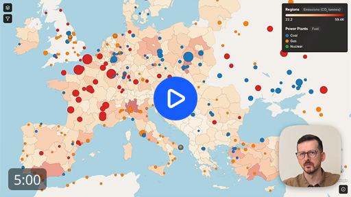
The setup that takes time is the publishing configuration - styling, filters, tooltips, view layouts. In the walkthrough video we build a published map from scratch in five minutes.
Which is right for you?
The honest answer depends on what you're trying to do. If your work centers on enterprise GIS, raster, spatial analysis, or field workflows, ArcGIS Online is the standard tool and the better fit. If you're publishing maps for clients, stakeholders, or website visitors, Topologis is built for that specifically.
Choose Topologis if you...
- Deliver finished maps to clients or stakeholders outside your org
- Embed interactive maps on your own or a client's website
- Want predictable per-seat pricing with no credits to track
- Need viewer-friendly per-view filter and layer controls without building a separate app
Choose ArcGIS Online if you...
- Run an organization-wide GIS with field workflows, surveys, and dashboards
- Need raster, geocoding, or in-browser spatial analysis
- Use ArcGIS Pro and want a unified Esri ecosystem
- Need REST API/JS SDK access, SSO/SAML, FedRAMP, or regional hosting
Get started
Try the complete toolkit - all features, all import sources, unlimited views and embeds. 14 days, no credit card.