Topologis vs Felt
Felt is a full GIS platform. Topologis is built for the last step - publishing finished maps to clients and stakeholders without account walls, view caps, or Enterprise procurement.


Side by side
Felt is a powerful web GIS platform for teams that need browser-based analysis, collaboration, dashboards, raster, and enterprise data connections. Topologis is built for a more specific workflow: publishing prepared GIS data as interactive maps that are easy to share, embed, and hand off.
Data
Felt accepts a wider range of formats and connects to data warehouses. Topologis accepts the formats consultants commonly deliver in and adds scheduled refresh, where Felt requires Enterprise.
Topologis | Felt (Team Plan) | |
|---|---|---|
| Vector formats (.shp, .gpkg, .geojson, .kml) | ||
| Raster | ||
| Spreadsheets (csv, Google Sheets) | ||
| Data warehouses (Postgres, Snowflake, BigQuery, etc) | ||
| Import from URL | ||
| Scheduled / automatic refresh | Enterprise only |
Editing & styling
Felt is the stronger choice for in-browser GIS work. Real spatial analysis, raster, table editing. Topologis assumes that work happens upstream in QGIS or ArcGIS and focuses on the publishing layer instead.
Topologis | Felt (Team Plan) | |
|---|---|---|
| Data-driven color & size (numeric, categorical) | ||
| Create and edit features in browser | Enterprise only | |
| Annotations (notes, photos) | ||
| Spatial transformations (buffer, clip, dissolve) | ||
| Heatmaps | ||
| Hexbin with 3D extrusion | H3, Enterprise only |
Sharing
Felt's Team plan covers map viewing and basic interaction. Topologis adds per-view configuration of which filters and layers viewers can control, plus embeds without an Enterprise plan.
Topologis | Felt (Team Plan) | |
|---|---|---|
| Share via URL | ||
| Invite collaborators | ||
| Embedded maps | Enterprise only | |
| White-labeled maps | Enterprise only | |
| API, SDK | Enterprise only | |
| Time sliders for viewers | Enterprise only | |
| Data filters for viewers |
Pricing & access
Felt's Team plan caps monthly views, meters data processing, and gates embeds behind Enterprise. Topologis includes all of it in the standard plan.
Topologis | Felt (Team Plan) | |
|---|---|---|
| Pricing | $23/mo per seat, billed annually $29/mo per seat, billed monthly | $200/mo, billed annually 25 people, 3 editors |
| Viewers | Unlimited | Unlimited for public maps 25 team members for private maps |
| Map views per month | Unlimited | 10,000 |
| Data processing | Unlimited | 5 GB/mo |
| Data hosting | 10 GB per seat | 25 GB |
Switching from Felt?
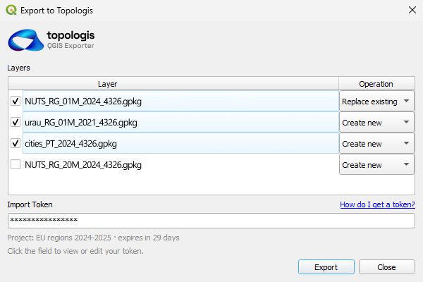
Topologis imports the formats you already use - Shapefile, GeoJSON, GeoPackage, KML, CSV, and Google Sheets. If your data lives in one of these, getting it into Topologis is a file upload, a URL, or a few clicks away in QGIS.
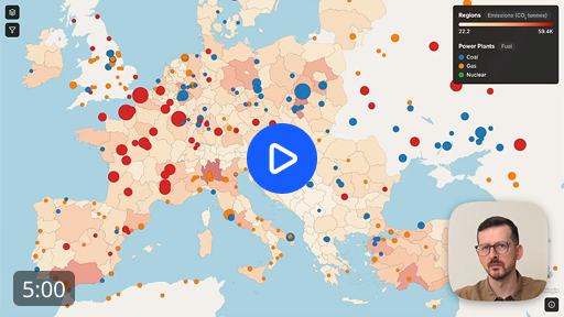
The setup that takes time is the publishing configuration - styling, filters, tooltips, view layouts. In the walkthrough video we build a published map from scratch in five minutes.
Which is right for you?
The honest answer depends on what you're trying to do. If your work centers on browser-based GIS analysis, raster, or live database connections, Felt is the better fit. If you're publishing maps for clients, stakeholders, or website visitors, Topologis is built for that specifically.
Choose Topologis if you...
- Deliver finished maps to clients or stakeholders
- Embed interactive maps on your own or a client's website
- Need scheduled refreshes from URL or Google Sheets
- Want predictable per-seat pricing without view caps or processing meters
Choose Felt if you...
- Do spatial analysis in the browser (buffer, clip, intersect, joins)
- Work with raster data, including styling and raster algebra
- Need real-time collaboration, comments, and annotations
- Connect to data warehouses (Postgres, Snowflake, BigQuery) - Enterprise
Get started
Try the complete toolkit - all features, all import sources, unlimited views and embeds. 14 days, no credit card.